The Himalayan nation of Nepal, whose geography is known for embracing the tallest mountain on Earth, finds itself unintentionally embroiled in an intense technological dispute at high altitude. By the beginning of May 2026, the base of Mount Everest had become less a site for adventurers than a battleground between the United States and China to establish drone superiority.
The ensuing contest, which is termed as the “US-China drone war Everest,” is an example of innovation versus production hegemony, which puts the Nepalese government in the tight spot of balancing its economically rewarding mountaineering industry against the underlying tensions of superpower politics. It started out as an innocent series of tests on logistics drones but grew in proportions that included revocation of flight permits and later regulation adjustments in the midst of the spring mountaineering season when adventurers converge at the summit of the world.
Nepali Times, in a post on X, claimed that Nepal abruptly imposed a temporary ban on drone flights shortly after Sergio Gor visited the Everest Base Camp to test an American-made Freefly Systems drone. The outlet noted that the restriction was lifted four days later, framing the development as part of a “DJI vs FREEFLY” narrative amid growing scrutiny over drone technology and geopolitical competition in the sector.
Timeline of the Drone Drama
The chronology of the events began in early May 2026 when the Nepalese government boldly decided to deny flight clearance to both Chinese-made DJI FlyCart drones and the recently developed US-based Freefly Systems’ Alta X Gen 2 drones, all used in the high altitude tests conducted at the Everest Base Camp.
DJI’s FlyCart drones from China, already known for their logistical uses, were demonstrating their heavy lifting capabilities in the thinner atmosphere close to the mountain summit area, whereas the US Freefly Alta X Gen 2 drone was entering the scene with the same intentions regarding airlifts. Sherpas and climbers spoke about “odd happenings” at the base camp, with drones flying above the camps, increasing tensions when the season is crucial for Nepalese tourism revenue earned from Everest climbing permit fees.
On May 5, 2026, the situation became more complicated when the Home Ministry of Nepal rescinded the ban in part, approving the use of industrial cargo drones under new regulations. But recreational and photography drones continued to be restricted, with any video or imaging operation necessitating approval. The change was a “welcome development for film producers and tourists” since cargo drones could operate again, which would lessen the hard labor porter loads traditionally associated with climbing Mount Everest.
Yet, the initial halt disrupted ongoing expeditions, stranding supplies and fueling whispers of ulterior motives—perhaps advanced mapping or reconnaissance near the sensitive Nepal-China (Tibet) border. The government’s rationale centered on “security sensitivities”, underscoring how a technological foothold on Everest could inadvertently militarize one of the planet’s most iconic natural wonders.
Technological Titans: US vs. China on the Peak
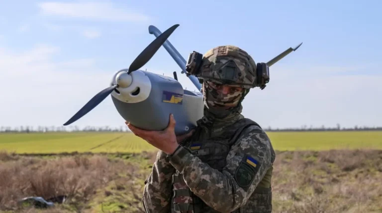
Two such companies lie at the center of this battle between the United States and China over drones on Everest. At one end is DJI, the Shenzhen-based drone giant that controls between 70-80 percent of the consumer drone market. It used its latest series, FlyCart, capable of carrying payloads above 30 kilograms at an altitude over 5,000 meters.
These drones were already successful in their trial runs in the Everest region, delivering medical supplies as well as waste materials from the base camp, thus providing relief from the physical burden that falls on the shoulders of the Sherpas.
“The drones were meant to make Mount Everest safe,”
according to observations in the magazine, Outside.
The US contender is Freefly Systems’ Alta X Gen 2, a modular heavy-lift drone designed for precision in extreme conditions. It is now marketed for identical supply and waste management tasks. Its entry into the market was clearly a shot across the bow at DJI’s dominance. Americans have proposed audacious plans such as robot climbs to the summit – a novel idea without precedent in Nepalese law.
These systems come with sophisticated technology, including autonomous flight, thermal sensors, and high-definition LiDAR mapping, which are much more than just transportation devices. It is suspected that these technologies may also be used as surveillance equipment to monitor areas around the Himalayan range, particularly the 1,400 kilometers of territory that Nepal shares with Tibet. While no information has been made available regarding the actual payload, number of flights, and altitude levels of the UAVs, the excitement can certainly be felt.
Nepal’s Geopolitical Tightrope
The intrusion into Nepal’s airspace is not just a matter of inconvenience; it is an indication of how vulnerable Nepal remains as a buffer nation between giants. The immediate revocation of permits by the Nepalese government was prompted by long-term security fears, especially since the drones had the ability to map areas near borders. The authorities decided to implement stricter policies on photography and videography to reduce the dangers while at the same time protecting their $5-$6 million revenue stream from Everest permits, which is vital for Nepal’s post-earthquake economy.
Traditionally, Nepal has been able to balance the geopolitical tensions between China and the United States through effective diplomacy, as demonstrated by its cooperation with China in the 2020 Mount Everest height survey project where the elevation was found to be 8,848.86 meters. This collaboration showed the dominance of Beijing with the help of infrastructural investments made as part of the Belt and Road Initiative. On the other hand, the US has been increasing its influence by way of foreign assistance and tourism ties. In this context, Nepal stands to lose out on one player, with overregulation leading to mountaineers using the northern slope of Mount Everest from Tibet, losing millions of dollars in revenues.
Broader Implications for Himalayan High-Tech
The incident goes further than base camp as it indicates that great power rivalry now extends to the most distant frontiers. While drones were already used on Everest since 2019 for ferrying oxygen tanks and monitoring the movement of glaciers, the magnitude has intensified. As a result, the use of drones in the US-China competition in Everest can be compared to the South China Sea standoffs elevated to 8,800 meters, with technology being used as leverage. There are numerous advantages that would accrue to climbers such as reduced death of porters who have died from accidents (totaling more than 300 on Everest alone), speedy rescues, and even avalanche forecasting. However, there are many dangers.
Nepal’s reaction to stop and refine the rules is indicative of pragmatism, but problems remain. There is no overarching policy governing drones in regions at great heights, while enforcement depends on poorly funded rangers surrounded by more than 1,000 climbers each year. Geopolitically, Nepal draws attention to the issues faced by smaller states: join Washington’s allies or accept Beijing’s generosity? In any case, cargo drones take flight again under surveillance; “Nepal has revoked flight clearances for both Chinese and US drones” sums up the evenhandedness of its decision. For filmmakers and sightseers, this new opening marks progress, but not everyone is pleased; YouTube is buzzing with renewed access, but Sherpas talk about how Everest has changed.
Future Skies Over the Summit
In terms of the future, Nepal is at a critical junction in this US-Chinese war of drones in the Everest region. Stronger legislation may become necessary, possibly requiring data localization or no-fly areas around the borders, reflecting a worldwide trend similar to what is seen in India and Bhutan. International mediation can create common practices for high-altitude drone operations, ensuring that Everest does not become an epicenter of contention. Economically, efficient use of drones will increase tourism and GDP through adventure sports, currently providing only 7-8% of Nepal’s GDP.
Ultimately, this bind tests Nepal’s agency. By May 14, 2026—climbing season peak—the skies have cleared somewhat, but the geopolitical clouds linger. As superpowers vie for a foothold on the world’s highest peak, Kathmandu’s chess moves will define whether Everest remains a symbol of human triumph or a pawn in technological empire-building. The “strange goings-on” at base camp may fade, but the lessons etched in thin air endure: in the drone age, no summit is too high for rivalry to reach.